BuildingLayer
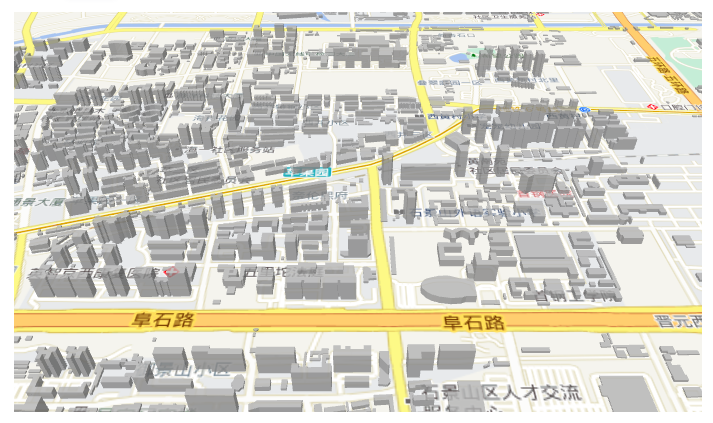
Building layers simulate 3D building effects and require source building data and floor height field information. For large datasets, vector tiling is recommended.
Example
Preview

Example Source Code
tsx
import React, { useEffect, useRef, useState } from 'react'
import ReactDOM from 'react-dom'
import { MbBuildingLayer, MbMap, MbTiandituLayer } from '@mapbox-react/core'

const App = () => {
  const [mapCenter] = useState([116.194322, 39.925238])
  const [zoom, setZoom] = useState(15)

  return (
    <div className="map-wrapper">
      <MbMap center={mapCenter} zoom={zoom} pitch={50}>
        <MbTiandituLayer types={['vec']} />
        <MbBuildingLayer
          heightInfoField="Floor"
          magnification={5}
          color="#acacac"
          geoJsonDataSource="/geoserver/building/ows?service=WFS&maxFeatures=60000&version=1.0.0&request=GetFeature&typeName=cestc:beijing-building-4326&outputFormat=application/json"
        />
      </MbMap>
    </div>
  )
}

ReactDOM.render(<App />, document.querySelector('#root'))API
PROPS
| 名称 | 描述 | 类型 | 默认值 |
|---|---|---|---|
| id | Layer ID | string | - |
| heightInfoField | The corresponding key in the source data for height information | string | - |
| magnification | Height magnification factor | number | 1 |
| base | Base height | number | 0 |
| color | Color value. Supports formats such as "#000000" and "rgb(0,0,0)" | string | #acacac |
| data | Data for the vector layer. Each object in the array must contain the required coordinates property and the optional properties property. Each object represents a point/line/polygon | VectorLayerData | - |
| geoJsonDataSource | GeoJSON data source. Can be set to a GeoJSON data link or a GeoJSON data object. Specification Link. If this property is set, the data property is ignored | string / GeoJSONSource | - |
| opacity | Opacity | number | 1 |
| maxzoom | Maximum zoom level | number | 22 |
| minzoom | Minimum zoom level | number | 0 |
| pickable | Whether the layer responds to pick events. If false, the component will not emit mouse-related events | boolean | true |
| show | Whether to show the layer | boolean | true |
| sourceId | ID of the layer's source. If this ID is set, both the geoJsonDataSource and data properties are ignored | string | - |
| sourceLayerName | Layer name in the source data. This property is effective when sourceId is set | string | - |
| sideGradient | Value of the Mapbox layer's fill-extrusion-vertical-gradient property | boolean | false |
EVENTS
| Name | Description | Parameters |
|---|---|---|
| onCreated | Map initialization completed event | - |
| onClick | Layer click event | object — Contains screen coordinates (pixel), longitude/latitude (coordinate), selected element properties, and originalEvent |
| onMouseMove | Mouse move event | object — Contains screen coordinates (pixel), longitude/latitude (coordinate), selected element properties, and originalEvent |
| onMouseLeave | Mouse leave element event | MapMouseEvent |
METHODS
| Name | Description | Definition |
|---|---|---|
| exportToGeoJson | Translate the layer's data to GeoJSON formatted text. If the layer's data source comes from a source component or a URL, output null. | ()=> object | null |
